 Government
A Quarter of a Century Building Australia’s National Land Parcel Dataset
Geoscape’s 25 years defining the shape of Australia

For over a quarter of a century, Geoscape Australia has built and maintained Australia’s most comprehensive national land parcel dataset – covering over 17 million lot and strata parcels, standardised across every state and territory.
Built with the state and territory land agencies we’ve partnered with for over 25 years, the dataset unifies eight separate land parcel sources – so our customers don’t have to.
This work continues to underpin smarter decision making across government, infrastructure, finance, real estate, and insurance.
More than a dataset, this is a national asset. Built through continuous investment and technical expertise, it reflects Geoscape Australia’s leadership in delivering and maintaining Australia’s accurate and trusted national foundation datasets.
A Living, Responsive View of Land
Capturing and validating this scale of data is a continuous process. Each month, updates from state and territory governments are processed, validated for geometry and attributes, and published to ensure high-quality, current coverage.
Last financial year we processed more than 6,000 data supplies and made tens of millions of updates to our land parcel data. These changes included:
• New records: reflected newly created or re surveyed parcels (e.g. subdivisions or improved geometry).
• Updates: refreshed parcel attributes relating to parcel lifecycle and associated metadata.
• Retirements: removed parcels that had been amalgamated, segmented, or otherwise superseded.
This continuous work keeps Australia’s land parcel data current and authoritative.
These monthly updates are possible because of our continuous partnerships with state and territory governments, whose land parcel data we validate, standardise and deliver as a single national service.
This makes the dataset living and responsive – able to reflect changes in land use, subdivision, planning decisions, and property boundaries in near real-time.
It also supports Cadastre 2034, the national strategy to modernise Australia’s cadastral system into a digital, federated model defining land rights, restrictions, and responsibilities.
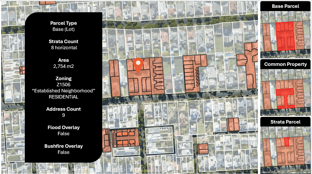
A view of land parcels insights
Created using aerial imagery © Aerometrex Ltd 2025, and Geoscape Cadastre and Planning Insights © Geoscape Australia 2025
Connected National Data for Complete Spatial Insight
Geoscape land parcel data is deeply integrated with other national foundation datasets Geoscape Australia maintains, including:
G-NAF (Geocoded National Address File) – trusted by industry as the source of verified Australian addresses
Geoscape Buildings – detailed 3D footprints and building attributes
With shared identifiers across these datasets, this enables a unified view of property, land use, zoning, development controls (from our Planning Insights dataset), easements, infrastructure and environmental constraints – providing comprehensive spatial analysis for planning, service delivery and risk assessment.
Two additional attributes enhance analysis:
• Base Layer Identification – flags base parcels for clear analytics and visualisation
• Strata Assignment – reveals vertical and horizontal strata counts for deeper property insight
Trusted Across Government and Industry
Geoscape land parcel data supports a wide variety of applications across Australia, including:
• The Australian Bureau of Statistics uses parcel data to design mesh blocks – the smallest units in Australia’s statistical geography.
• Before You Dig Australia (BYDA) enhances its safe excavation process with our address verification, improving the customer experience and reducing response times.
• APA Group uses parcel data to manage national gas infrastructure more efficiently, improving operational oversight and planning.
This is why our data is trusted by banks, insurers, utilities, and all levels of government.
Evolving for the Next 25 Years
Geoscape Australia isn’t just maintaining data – we’re actively developing the tools needed to meet Australia’s emerging spatial challenges. Current development areas include:
• Jurisdictional border alignment for seamless national analysis
• 3D parcel modelling to support urban growth and infrastructure planning
• Enhanced land use and temporal data to support productivity and risk analysis
These capabilities are vital to tackling complex, location-dependent issues such as housing supply, disaster response, infrastructure development, and climate resilience.
Smarter Decisions Start with the Right Data
Geoscape national land parcel data delivers detail, continuity and integration that few can match.
Contact us to explore how tailored insights can support the decisions that matter most to your organisation.
