 Government
Location Intelligence and Everyday Living Quality
Using location data to assess comfort, convenience, and liveability

Authored by: Dr. Stuart Barclay
Australia’s housing crisis involves more than just cost; it is also about where and how people live. A home’s location can influence every aspect of the quality of life it offers its residents.
In line policies such as NSW Government’s target of building 377,000 well-located homes by mid-2029, we recognise that a property’s location can profoundly impact everyday quality of life, from ease of travel to digital connectivity.
To meet these diverse needs, Geoscape has developed seven location intelligence indices, known collectively as the Housing Suitability Index. These indices measure a neighbourhood’s capacity to meet residents’ needs:
1. Liveability
2. Desirability
3. Suitability
4. Vulnerability
5. Insurability
6. Sustainability
7. Accessibility
When used together, these indices provide a clear framework for evaluating a neighbourhood’s overall potential.
Group 1: Everyday Living Quality
We begin by examining two key indices that shape day-to-day comfort and convenience: Livability and Desirability. Together, they form our first category – Everyday Living Quality.
Liveability
Focus: How a location supports wellbeing and comfort.
Key Factors:
Green Space – Parks and tree cover that help moderate temperatures and encourage outdoor activities
Noise Levels – Reduced noise for a calmer, healthier environment
Urban Design – Pedestrian-friendly layouts and communal areas that promote social engagement
Connectivity – Access to reliable broadband (NBN) and strong 4G/5G mobile coverage for modern communication, remote work, and digital services
Geospatial data plays a key role in Connectivity. For example, Geoscape’s work with a major telecommunications provider has helped optimise 4G and 5G signal coverage across Australia by mapping elevation, land cover, and buildings in high detail – ensuring better connected communities from the ground up. Learn more here
Desirability
Focus: How accessible and secure a neighborhood is.
Key Factors:
Proximity to Amenities – Schools, healthcare, retail, and cultural venues within easy reach
Safety Indicators – Low crime rates and a positive community reputation
Community Appeal – A welcoming atmosphere that supports long-term residency
How Location Intelligence helps
Geospatial data provides the foundation for measuring each index. By mapping environmental features, identifying gaps in essential services, assessing connectivity coverage and analysing safety indicators, decision-makers can spot areas for improvement.
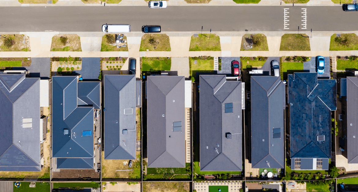
As seen in the above image, some urban residential areas have little tree cover. This often results in higher air temperatures, leading to increased energy use for cooling. This could be reduced by planting more trees, using renewable energy sources, or installing light-coloured roofs.
Mapping Liveability and Desirability also helps with:
Resource Planning: Pinpointing neighbourhoods that lack healthcare or retail services, so they can be prioritised for new facilities
Policy and Development: Setting minimum standards for green spaces, safe walkways, bicycle paths, and reliable access to amenities
In this way, data-driven methods convert raw information into insights that guide public and private initiatives, ultimately creating neighbourhoods that effectively serve their residents.
Greenfield and Brownfield
Two development categories, greenfield and brownfield, illustrate how these indices can be applied:
Greenfield: Undeveloped land, such as farmland or open space, where new communities can be planned from the outset
Brownfield: Previously developed land in existing suburbs or industrial zones, which may need remediation or repurposing before redevelopment
Greenfield Developments
From the earliest design phases, urban planners can use liveability and desirability indicies to shape greenfield communities. Green space and tree coverage should be treated as essential infrastructure, while walkable access to retail facilities and schools can help reduce road traffic and build community engagement. Ensuring robust digital connectivity from the outset further enhances liveability and economic potential.
Brownfield Developments
Redeveloping brownfield sites can be more complex, but core design goals still apply:
– Specify minimum standards for green space
– Build with pedestrian accessibility to local amenities in mind
– Upgrade digital infrastructure to meet modern connectivity requirements
Looking Ahead
Everyday Living Quality is just the first step. In the next article, we’ll explore Housing Feasibility by examining Suitability, Vulnerability, and Insurability. Finally, Part 3 will focus on Future-Proofed Housing, covering Sustainability and Accessibility.
By understanding all seven indices, policymakers, developers, and residents can plan well-located homes and communities that remain liveable, resilient, and inclusive for years to come, effectively meeting diverse community and digital needs.
