Coordinate Reference Systems and GDA2020
What is GDA2020? And why is it important?
Australians rely on satellite positioning systems daily – to use a smartphone for navigation, order a ride-share service, dispatch an emergency vehicle or fly a drone, for example.
In anticipation of the growing use of positioning technology, the Australian Government committed $225m to provide 10cm (or better) accurate positioning to anyone, anytime, anywhere in Australia. It’s a significant improvement on the 5-10m accuracy you get now using GPS-enabled devices, but it relies on an update of Australia’s coordinate reference system. (Intergovernmental Committee on Surveying and Mapping, ICSM).
Satellite positioning systems calculate a device’s location using coordinates relative to the centre of the Earth, which is fixed. Australian addresses, roads, property boundaries and other features are mapped to Australia’s tectonic plate, which is constantly moving.
So, some key points:
- The Geocentric Datum of Australia 1994, or GDA94, has defined the coordinate reference system for Australian location data.
- Updating to GDA2020 will ensure Australian spatial data can be more closely aligned to positions observed using GPS (ICSM).
- Our API customers can now select and receive data in either datum.
How does a configurable Coordinate Reference System (CRS) come into play?
To support more than one CRS, we need a mechanism that enables selection of the CRS used in our API responses and, in the future, how we interpret requests. We’ve moved ahead of the standardisation efforts of the Open Geospatial Consortium (OGC) and implemented CRS selection by content negotiation. This allows us to continue to serve customers with GDA94 and enables those that want to move to GDA2020 to select that CRS and receive data in the new datum.
You can read more about the method we’ve implemented here.
How to select your CRS
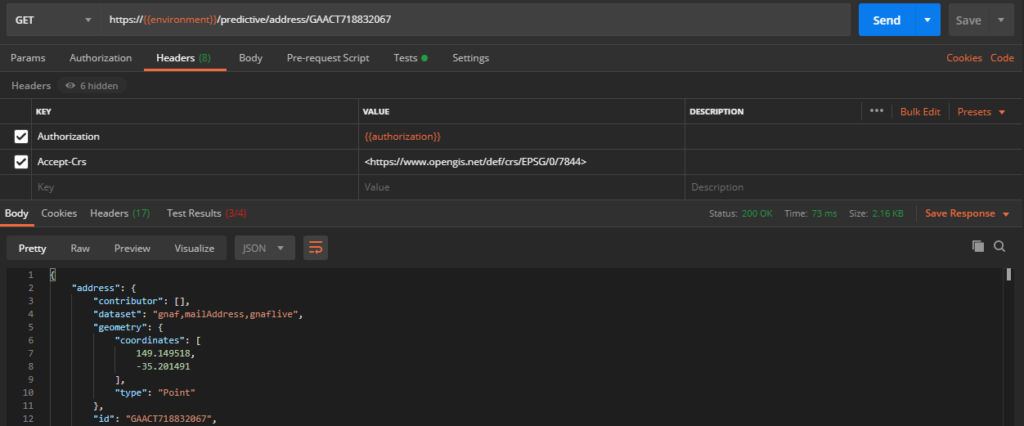
To use this new feature, all you need to do is pass in an additional header in the form of an ‘Accept-Crs’ header. Our backend system reads this new header, and we perform a transformation of the spatial location (latitude and longitude) to return a spatial point in the correct datum for your use.
Read more about making a call with headers.
Confirmation of a successful request and response
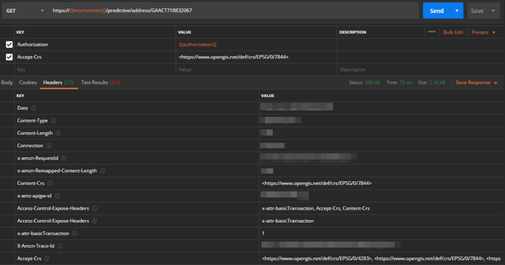
We’ve implemented new response headers that confirm we’ve not only understood the request, but also returned the data in the requested CRS.
Review the response and look for the ‘Accept-Crs’ header, which defines a list of supported CRSs, and the ‘content-Crs’, which describes the CRS used in the response.
Read more about the API response structure.
Notes on our implementation
Rounding
Because we’re transforming the geometry, the resulting coordinate values can have many decimal places. The decimal places are a function of the transformation, not a reflection of actual positional precision. Because of this, we’re rounding the result to 6 decimal places, which better reflects the accuracy of the data.
Default behavior if no CRS is requested
To ensure no impact on current customers, we’re continuing to default to GDA94 when no CRS is selected.
WGS–84 reference
World Geodetic System 1984 (WGS-84) defines the earth-centred, earth fixed satellite positioning reference system. Given that Earth’s tectonic plates shift, datums like this are referred to as dynamic datums because their coordinates are constantly changing.
For accuracy, coordinates of dynamic datums should be accompanied by a time component, referred to as a coordinate epoch. Because our default datum is GDA94, we decided to use a coordinate epoch of 1994.0 for WGS84 as our starting point. As GDA94 and WGS84 use closely aligned reference frames, this results in coordinates being almost identical for all practical purposes.
We have no plans right now to use a more recent coordinate epoch for WGS84, but will review this in the future based on consultation with our customers.
Give us feedback, please.
As always, we ask you, our developers, what we should be doing differently. How can we make our APIs more useful to you?
Please get in touch:
Email: support@geoscape.com.au
Twitter: @GeoscapeDevs
Support: Customer Support Portal
Read how the Energy & Water Ombudsman NSW uses Geoscape APIs to maintain address data integrity.