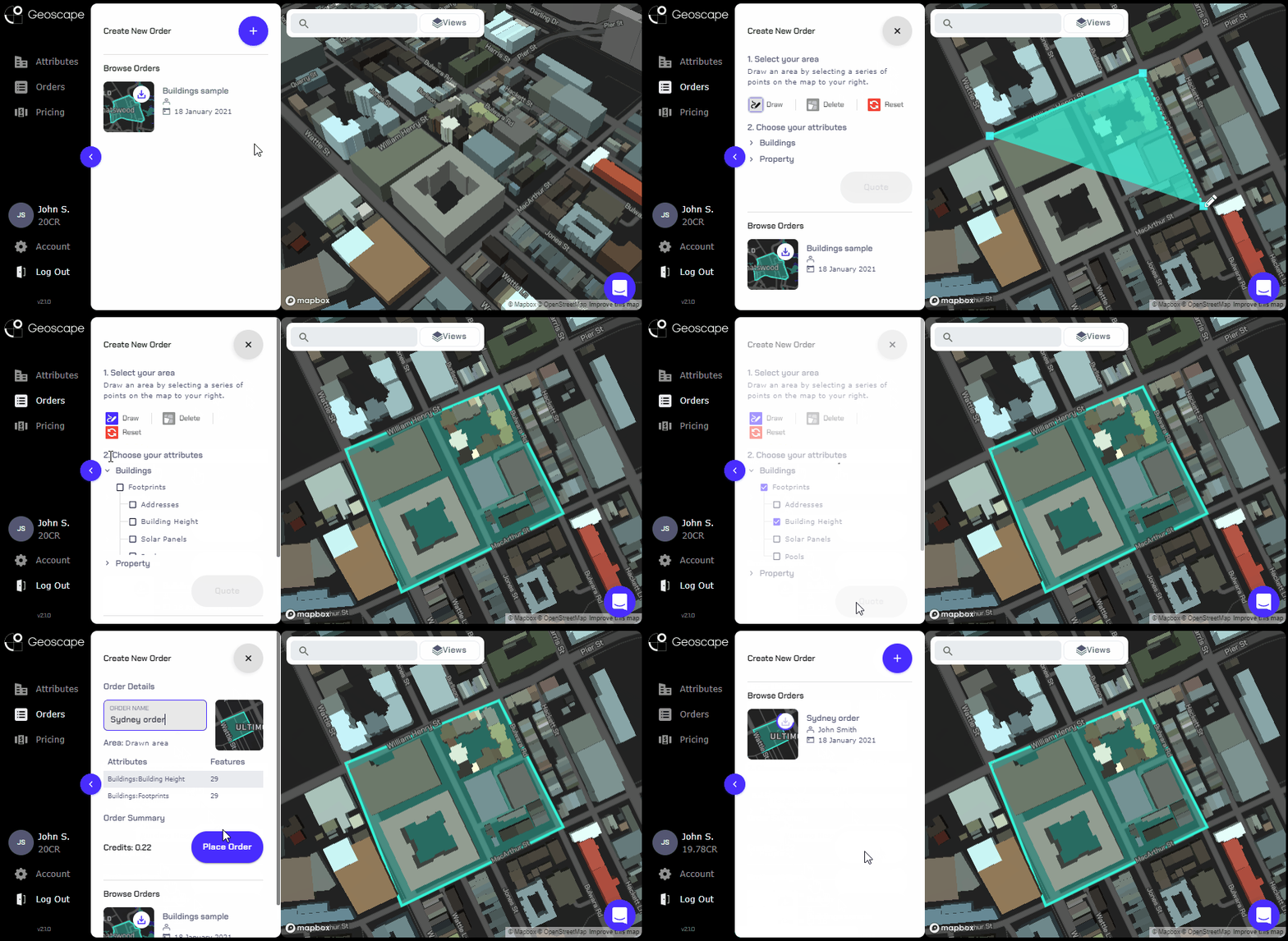
Australia’s best location data. Make it yours in just three steps.
Our platform makes it easy to access our world class data on demand. Reliable. Affordable. Accessible.
1. Select Area
Upload your own shape file, or draw your required area using our pen tool.
2. Choose Attributes
Choose from our many authoritative attributes to get exactly what you need.
3. Download Orders
Enjoy perpetual access to your data, and easily integrate it into your tools and workflows.

Data Plans
Monthly and annual data subscriptions offer flexibility for all budgets. Ordering data for a standalone project? One time purchase pricing is now available.
Basic
- 20 credits/mo
- $25/credit
Standard
- 75 credits/mo
- $16/credit
Pro
- 250 credits/mo
- $12/credit
Custom
- Need something different?
Basic
- 300 credits
- $16.67/credit
Standard
- 1,085 credits
- $11.06/credit
Pro
- 3,750 credits
- $8/credit
Custom
- Need something different?
Data Available
Buildings
Buildings data provides building outlines for all buildings with a roof area at least 9m2 across Australia. You can also select attributes for the 15 million+ buildings across Australia, including; Heights, Addresses, Pools, Solar and building footprints.
Planning
Planning data will provide the Planning attribute for each cadastral parcel in the area selected. It includes information such as Zone Type and Zone Descriptions.
What data formats can I get?
Buildings data is represented as polygons and is currently available in ESRI Shapefile (*.shp, *.shx, *.dbf). Planning data is available in a Shapefile (.shp).
Free data quotes
Enhance the quality of projects and bids to improve client satisfaction with high-quality data and free quotes, whenever you need them.
Reduce costs
Reduce time spent manually sourcing and validating data with ready-to-use data on demand.
Improve productivity
Improve teamwork with enterprise plans, order history and flexibility to access data anywhere, anytime.
Data Pricing
Geoscape location data is accessed by spending credits you receive with your paid subscription or one time purchase. Credit pricing is as follows:
| Name | Unit Measured | Credit Cost |
|---|---|---|
| Building Footprints | Per Building | 0.0045 |
| Building Heights | Per Building | 0.003 |
| Solar Installation | Per Building | 0.003 |
| Swimming Pools | Per Building | 0.003 |
| Formatted Addresses | Per Building | 0.0015 |
| Cadastre Parcel | Per Parcel | 0.0045 |
| Planning Zones | Per Parcel | 0.003 |
Pricing FAQ
Which currencies do you accept?
Invoices issued by us must be paid in Australian dollars. Geoscape uses Stripe for subscription payment processing, which supports over 135 currencies. Payments to us are ultimately settled in Australian dollars. You may incur foreign exchange fees by your credit card company for any conversion, or international payments to Australia.
Are these prices inclusive of GST?
Yes. The subscription prices listed on this page are inclusive of GST.
Do I need to use all of my credits each month?
Your credits must be used within the time of your subscription term, plus one additional month. For example, if you have signed up for a monthly plan on 1 April 2020, these credits must be used by 1 June 2020.
Will I receive ongoing updates to an area’s location data?
No. You will need to use your credits to order updated location data as it becomes available.
Can I purchase additional credits for a single use?
No. You will need to upgrade your organisation’s subscription to receive additional credits. Please see the top of this page for the credit allowances attached to individual data subscription plans.
Do I need a paid subscription to generate quotes?
No. Anyone with a registered Geoscape account may generate a credit quote for location data. Geoscape account registration is free.
Can I pay against an invoice?
Yes, we can accommodate this. Please contact sales with your commercial requirements.
Pinpoint-accurate data. Flexible pricing. Seamless integration. Register your Geoscape account now.