With cities becoming increasingly denser, transport noise levels are a rising area of concern.
Environmental noise experts, Ambient Maps, recently developed the world’s largest 3D representation of transport noise data for every address in Australia. However, Ambient needed a reliable and accurate buildings dataset to anchor its transport noise map.
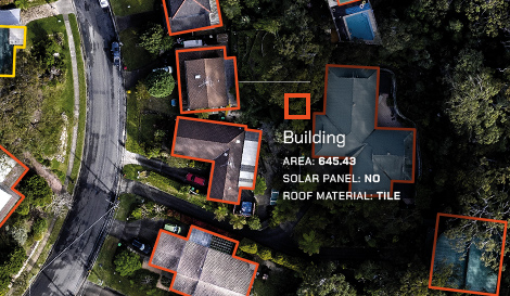
The biggest requirement for Ambient was detailed and accurate buildings data which would form a crucial aspect of its modelling as the presence of buildings directly or indirectly affects noise levels.
Greater levels of accuracy from Geoscape Buildings data derived from satellite and aerial imagery meant Ambient could incorporate building areas, heights,
land zoning and addresses on a consistent national scale. With this increased level of accuracy, the 3D noise map can support a variety of use cases such as automatic valuation models (AVMs) in property pricing.
Download the case study to understand the challenge faced by Ambient, the solution and the benefits.