Data on demand simplifies noise modelling
How subscription access to Geoscape spatial data simplifies noise modelling for SLR Consulting.
Specialised environmental consultancy, SLR Consulting, needs reliable data on building outlines and heights for noise, air quality modelling and visual amenity assessments to forecast the impact of major facility and infrastructure projects. To do this, SLR Consulting accesses Geoscape’s ready-to-use spatial data whenever they need it via a flexible data plan.
It’s the personalised ‘on demand’ approach to accessing Geoscape data that is streamlining their work. Plus, it fits with SLR Consulting’s need to respond quickly and confidently to client needs on a project-by-project basis.
A big player in a growth sector, SLR Consulting delivers acoustic and air quality modelling, engineering, environmental approval and compliance across the Asia-Pacific region, with 11 offices located in Australia.
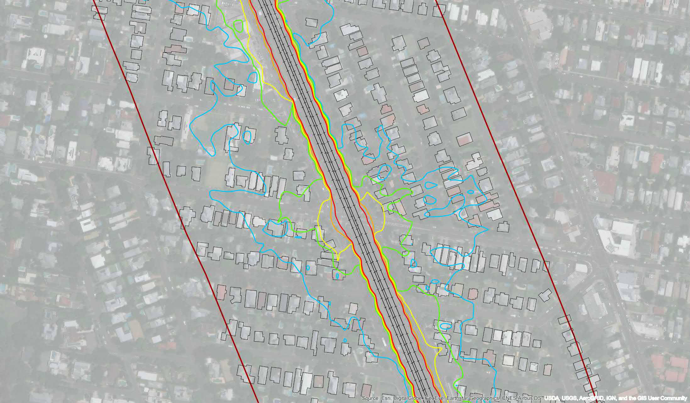
In only a few months, SLR Consulting has extracted tailored Geoscape data, including building outlines, heights and addresses, for areas from Pakenham in Victoria, to northern Queensland and Lakelands in Western Australia. It’s been central to their decision making.
Challenge
Multiple projects, differing sizes, cross-jurisdiction data needs
For a busy organisation working with many different clients, SLR Consulting’s need for spatial data can be sporadic.
“We may need Geoscape data at any time on any day,” said Peter McGown, technical discipline manager for SLR Consulting’s GIS & Information Services. “We might do three requests in a week or one request a month. It depends on what projects we’re working on.
“Accessing Geoscape on demand has made it more efficient for us. Before this data was available, many projects required manually digitising buildings and extracting heights from multiple different sources or making assumptions on heights. The data is now ready to use in our modelling and we can say to our clients that we have access to data that makes our models more accurate.”
With Geoscape, SLR Consulting has assurance the data is reliable and easy to access for their specific project needs. They can select only the data they need, choosing from 15,000,000+ buildings Australia wide.
“When we’re justifying our methodology to our clients, we tie it back to the authoritative data from Geoscape, which eliminates potential risk.”
Reducing processing time and cost
Beyond the accuracy and reliability of the data, being able to grab clips of the data at a moment’s notice is a win-win for the consultancy. A single plan simplifies access and controls data costs.
“We’re the interface or data custodians for our broader APAC business, but we’re based all over Australia, so giving the GIS team authority to access data directly makes it much more automated,” said Peter.
The beauty of accurate, instant data quotes is that this automation can be built into project management systems, especially for larger companies. Even with a corporate subscription, they can still run a per job cost for accurate cost estimation.
“In the past when we needed to potentially digitise thousands of buildings, we would base our costs on an estimated number of hours. With Geoscape, it’s a quicker process. We decide what we want in a particular area – say an area of 100 metres or 3 kilometres – which has X number of buildings, and we get an instant idea of the cost for that data. We incorporate that into our costs, but also provide those costs directly to the client.”
Attributing costs to each project is more streamlined.
Projects large and small
“We will identify key descriptors around a certain project, whether it be a road construction, a modelling operation, or the construction of a new tunnel,” said Peter. “With Geoscape, we say we need all the buildings in the area, their heights as well as the addresses – it takes out an extra layer of processing that we don’t have to do.”
It also caters for anything from localised construction projects up to major rail or road impact assessments across state boundaries. Modellers prefer to reduce state or jurisdictional variations in data, making Geoscape’s truly national representation particularly appealing.
“SLR Consulting has been working on a range of rail and road projects,” said Peter. “Geoscape has been very valuable because there isn’t building data available that is comparable to Geoscape data.”
“The way Geoscape is delivered is very flexible.”
Seamless integration
Another benefit for Peter is the way the data is delivered. The Shapefile – an accepted GIS format –integrates cleanly with noise modelling and air quality monitoring software.
“The data comes through us and we’ve had no issues integrating it with software including SoundPLAN or other modelling software,” said Peter.
Seamless integration. Increased productivity. Reliable modelling.
Register your Geoscape account now.