Geoscape address APIs streamline service delivery for NSW Government customers
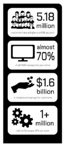
1,000,000+ API calls a week enable customer address verification based on data that’s updated daily
Many governments rely on online transactions to get support and services to customers.
With millions of online government forms being completed every day, the public expect a quick and seamless process. From registering a birth to applying for a fishing licence, accurate validation of address data helps users progress smoothly through a form all the way to ‘submit’.
When it comes to whole-of-government address management, NSW Government agencies and departments turn to DCS Spatial Services. A trusted unit of the NSW Department of Customer Service, Spatial Services enables fast, collaborative and efficient digital solutions across the state.
At the core of its address verification services are Geoscape APIs.

WHY ADDRESSES MATTER
Effective and efficient government service delivery relies on up-to-date, accurate and easily accessible address data. Knowing a customer address is a critical element in verifying their identity and what grants or services they may be entitled to.
To do this, DCS Spatial Services developed an address tool called NSW Point for NSW state government agency use. It allows users to select an accurate physical or mailing address in an online form. Geoscape APIs are the backbone of NSW Point. They enable address verification using reliable and authoritative national address data that’s updated daily.
“When looking into developing the services in-house, we soon worked out that a state-based system rarely stops at the border,” said Dr Greg Windsor, Manager of the Administrative Spatial Program. “We needed consistent national address coverage for issues we’re facing now, like COVID-19 border permits.”
The Geoscape APIs – Predictive API and Addresses API – not only cover the whole of Australia, they also use source data that is consistent across jurisdictions and updated daily through longstanding supply arrangements with each Australian state and territory. The APIs enable machine-to-machine checking of address data in the moment that it’s required.
“While some providers may offer APIs with only one reference dataset, with the Geoscape APIs we can validate against multiple sources,” said Greg.
“And there are thousands of address amendments made every month in every state. We can be sure the most up-to-date information is there with the Geoscape APIs.”
DCS Spatial Services can also aggregate and map government service delivery locations to multiple administrative boundaries, including LGAs, ABS Mesh Block, localities and electorates using Geoscape APIs.
“We needed consistent national address coverage for issues we’re facing now, like COVID-19 border permits.”
Dr Greg Windsor, Manager of the Administrative Spatial Program, Spatial Services, NSW Department of Customer Service
CUTTING DEVELOPER TIME
When the DCS Spatial Services team was developing a vision for better digital design, they wanted to achieve a more consistent experience for the public, while also cutting down the effort for NSW Government departments.
Mark Hendry, Business Development Officer, Service Delivery for DCS Spatial Services says NSW Point became one of the first reusable components of the NSW Government’s ‘Digital Design System’.
“In the past, there was no commonality in how each department implemented address validation. Development teams would go out and start from scratch every time,” said Mark. “By having a commonality with NSW Point, we can ensure good results by using reusable components.”
Geoscape APIs have a wide range of customisable options for developers, so they can be tailored to meet the needs of many applications within government. With the Predictive API, developers can control what type of address is suggested – physical or mailing or both, and whether suggestions include alias addresses. The ‘include’ parameter in the Addresses API controls whether information like LGA, ABS Mesh Block, or other administrative boundary (or all of them) are returned. This functionality is incorporated into NSW Point.
NSW Point uses Geoscape APIs to:
- verify addresses collected by government departments against authoritative national address datasets to ensure their validity – in real time
- geocode address data for spatial analysis
- standardise predictive address validation in online forms across NSW Government
Service NSW formed a partnership with DCS Spatial Services to use NSW Point in their online forms. Service NSW is a one-stop-shop for government information and services, and previously used a different source for address verification, finding it wasn’t always accurate or reliable.
“NSW Point is now being used for many grants and programs, allowing us to put in checks and controls that save the customer time,” explained Chris Tandy, Service NSW Principal Product Manager.
The Geoscape APIs offer seamless, scalable and secure integration – significantly reducing the cost and effort associated with the development and maintenance of web applications that require address data. Plus, there is now less reliance on technical geospatial skills within each department.
Tech leads, developers and data managers in NSW Government departments can bypass the procurement and research steps when they need address verification services and go straight to DCS Spatial Services to get API keys, guides and support – all within days.
Given DCS Spatial Services maintains the purchase arrangement with Geoscape, it saves each agency having to source and pay for an API.
“It’s great value for money as we can buy as one entity for the NSW Government,” said Greg. “And it makes governance easier with one account holder.”
A CUSTOMER-CENTRIC APPROACH

A seamless data entry experience ultimately improves the customer experience.
“We wanted government transactions to be quicker, so users had to input fewer keystrokes, and to give us greater accuracy,” explained Greg. “We also wanted to join more information together for greater insights.”
And in times of crisis, deploying a functional new form for customer permits or support payments needs to happen rapidly.
“Government agencies don’t have time for massive online systems, or to go through weeks or months of testing – they need to deploy online forms urgently in times of emergency,” said Greg.
The bushfire crisis and COVID-19 are prime examples. For instance, Service NSW used NSW Point in online application forms where small businesses impacted by recent bushfires could apply for grants. They also created border permit forms for people to apply to enter NSW under COVID-19 restrictions.
“With the border permits, we use NSW Point to determine exactly where people are located within the border zone, which then determines what type of border permit they’re eligible for,” said Chris. “This saves time because we can match eligibility and entitlement for a range of programs based on the person’s address.”
Chris notes that millions of dollars in payments have gone out to those who need them in rapid time with the help of these tools.
Plus, many Service NSW programs use NSW Point to streamline online applications, including Active Kids and Creative Kids vouchers, seniors’ energy rebates, export assistance grants, and the regional seniors’ travel card.
GEOSCAPE APIS HELP NSW GOVERNMENT DEPARTMENTS WITH:
- Easy integration with websites and apps
- Fewer keystrokes for greater accuracy and speed in transactions
- Reduction in fraudulent activity
- Savings – time and cost
- Cross-department collaboration – sharing data is easier and quantifiable
- Spatially enabling large databases
- Simplified procurement
- Faster development of forms
- Real-time analysis and response
A CRITICAL ANALYSIS TOOL
As with any government, there is a massive flow of data associated with customers registering their vehicles, moving house, applying for rebates, or enrolling their children in school. Knowing where transactions are happening can provide greater insights into the types of government support and services required in particular areas at specific times.
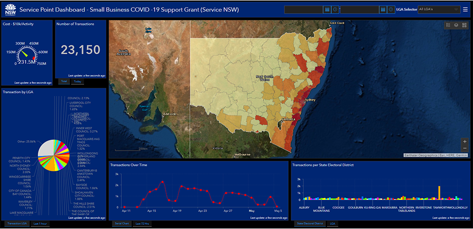
Service Point is another tool developed by DCS Spatial Services that uses Geoscape APIs. Using Service Point together with NSW Point, NSW Government departments have access to real-time analysis and reporting on where customer transactions are occurring and where government services are being accessed.
“Location-based reporting is critical these days to monitor what is happening in the real world,” said Greg. “If you want to make sure the decisions you make are relevant to the community, you need the numbers and spatial information for what is happening on the ground.
“There has never been a way to standardise that before, because of privacy and a time lag in getting data for decision making. Now we’re making decisions based on today.”

Service Point captures several data points from agency systems, including:
- location
- service provider
- type of service
- transaction date.
The data is then displayed on a simple, interactive dashboard to provide rich intelligence on how policy is working in practice. Decision makers can see, at a glance, how school enrolments are progressing by suburb. Or where vehicle registrations are occurring by local government area. Or where business grant applications are being lodged based on a statistical area.
Service improvements – like extra on-the-ground support or information – can be rolled out to areas based on need, which is especially critical in times of emergency.
NSW Point and Service Point enable trends to be identified quickly. The insights help inform policy development, enable improved government service delivery, and facilitate a customer-focused approach by the NSW Government.
“For the bushfire and COVID-19 grants, we’ve been able to report by LGA, electorate and usage, and this has informed policy decisions,” said Chris. “The data goes to different agencies and to the Minister, helping inform when other LGAs may need to be added to the eligibility boundaries based on impact.”
“It’s helping us cut down on costs and collaborate more across departments,” said Mark.
PRIVACY ASSURED
Greg notes that government agencies feel more secure when the only organisation involved in what comes through their transaction list is another government agency.
“For instance, if an address validation is needed for a drug search for police, that information stays within government.”
This level of security is backed by a range of other systems to ensure data is private, protected and individuals cannot be identified.
“We adopted a privacy by design approach,” said Greg. “We de-identify through geotagging so no personal details are used within Service Point and we always use functional separation of transactions. It’s controlled access and all pre-processing is done before it is downloaded to us so the data cannot be re-engineered.”

A 360-DEGREE FEEDBACK LOOP
Greg says DCS Spatial Services were heavily involved in driving the user requirements for Geoscape APIs, being one of the first users when the APIs were released in 2018.
A collaborative relationship continues today and is vital for the continuous improvement of the APIs.
“We’re working towards our goal to have the best address validation service. Not only are our customers pushing us for refinements, we’re also able to talk to Geoscape about changes. When an update is released by Geoscape, we can let our customers know that their feedback has been incorporated,” said Mark.
“Developers across NSW agencies also develop an in-depth knowledge of working with NSW Point and they become part of the development cycle so we’re all continually improving.”
GEOSCAPE ADDRESS SERVICES
- The Predictive API is an address verification service. It has predictive text and auto-complete functions and suggests possible address matches as users type in online forms – customers or staff. It verifies the addresses entered against trusted sources. It also appends geographic coordinates to each address to enable them to be mapped to a location.
- The Addresses API enriches address data by attaching additional attributes to each address, such as Local Government Area (LGA), Australian Bureau of Statistics (ABS) statistical area / Mesh Block, and state and Federal electorates, to enable analysis and reporting.
Address data integrity. Flexible pricing. Seamless integration.
Register your Geoscape Developer account now.