Surface Cover
Metadata Statement
Metadata for the Metadata
- Metadata Identifier: Surface Cover
- Scope: Surface Cover Dataset
- Time: 02/02/2022
- Responsible Party:
- Contact Point: Michael Dixon
- Organisation: Geoscape Australia
- Position: Chief Data Officer
- Telephone: +61 2 6260 9000
- Delivery point: Unit 6, 113 Canberra Ave Griffith ACT 2603 Australia
- Access, Use, Security: Information supplied within the metadata may not be copied without referencing Geoscape Australia.
- Standard: ISO 19115-1 based on the ANZLIC/ICSM Metadata Working Group https://www.icsm.gov.au/sites/default/files/Poster%20-%20Best%20Practice%20for%20Datasets%20Metadata%20v1.pdf
- Language: English
Resource Metadata
- Title: Surface Cover
- Identifier: Surface Cover
- Abstract: Surface Cover is a raster dataset representing land cover categories across Australia. Urban Surface Cover has coverage in pre-defined urban locations across Australia at 2-metre resolution, while the National Surface Cover has complete national coverage at 30-metre resolution.
- Purpose: The purpose of the Surface Cover product is to represent different types of land cover for use by industry and government in geographic information systems and/or other information systems.
- Time: Urban Surface Cover updates are applied and released on a quarterly schedule. National Surface Cover achieved complete coverage of Australia for the October 2018 release. There are currently no plans to update this layer from new capture. The source data capture dates range between 2014 and 2017.
- Responsible Party:
- Contact Point: Geoscape Support
- Organisation: Geoscape Australia
- Telephone: +61 2 6260 9000
- Facsimile: +61 2 6260 9001
- Delivery point: Unit 6, 113 Canberra Ave Griffith ACT 2603 Australia
- Access, Use Security
- Legal Constraints: The dataset is available under licence from Geoscape Australia and authorised partners. Data usage is in accordance with the Geoscape Copyright Notice and Disclaimer available https://geoscape.com.au/legal/data-copyright-and-disclaimer/
- Security Constraints: N/A
- Use Limitations: The Surface Cover dataset is a representation of surface objects and related characteristics. Remotely sensed inputs including imagery sources and elevation models have absolute and relative positional accuracy limitations and so precise navigation with respect to represented objects may require additional qualification.
- Releasability: The dataset should only be distributed in accordance with the licence under which it has been accessed.
- Extents:
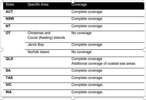
West Bounding Longitude: +100 East Bounding Longitude: +160
- Reference System:
- Spatial Reference System: GDA94 and GDA2020
- Vertical Datum: The Australian Height Datum (AHD)
- Temporal Reference System: Gregorian calendar
- Language: English
- Format: The data is made available in the GeoTiff and ESRI Shapefile formats, other formats may be available through distribution partners.
- Additional Information: A Product Guide for the dataset is available from Geoscape Australia. Release Reports are made available at the time product updates are released.
- Linked Services & applications: Related products and services are available via www.geoscape.com.au
- Status: Complete
- Lineage:
- The Surface Cover theme consists of two layers: (1) Urban Surface Cover and (2) National Surface Cover. The theme consists of a digital pixel representation of the different types of ground cover of Australia. Each layer represents a different pixel resolution and coverage: Urban Surface Cover is a two-metre resolution covering pre-defined areas classified as “Urban” (see below), while National Surface Cover is a complete national coverage at a thirty-metre resolution (i.e. Urban and Rural coverage).
-
Data quality and potential capture timelines will vary across Australia based on three categories. Each category has been developed based on several factors defined by the population distribution (categorised based on population size), industrial/commercial activities, the probability of natural events (e.g. flooding) and the image source.
- Urban (satellite source) – areas with a population greater than 200, or with significant industrial/commercial activity in a visual assessment, digitised from satellite imagery
- Urban (aerial source) – areas with a population greater than 200, or with significant industrial/commercial activity in a visual assessment, digitised from aerial imagery
- Rural – all other areas
- Associated Resource: Further product documentation including a Product Guide and a Release Report are published at the time of a dataset update.
- Maintenance:
- Urban Surface Cover updates will be applied and released on a quarterly schedule.
- There are no plans to update the National Surface Cover this layer from new capture. The source data capture dates range between 2014 and 2017.
- Storage: The Surface Cover dataset is managed by Geoscape Australia.
- Distribution: The dataset is available from multiple locations.
- From Geoscape Australia and authorised re-sellers;
- Organisation: Geoscape Australia
- Telephone: +61 02 6260 9000
- Mailing address: Unit 6, 113 Canberra Ave Griffith ACT 2603 Australia
- Authorised Resellers: Available via https://geoscape.com.au/partners/
- From Geoscape Australia and authorised re-sellers;
- Topic Category: Dataset metadata
- Keywords: Surface Cover, Trees, Tree height, Surface Cover datasets, built environment, Bare Earth, Road and Path, Grass, Trees, Unspecified Vegetation, Built-up Areas, Water, Buildings, Cloud, Shadow, Swimming Pool.